Monday, June 30, 2008

Mt. Jefferson Failed Attempt

Too big with too little time is how I would describe our effort to climb Mt. Jefferson this weekend. Kalin and I thought we'd have enough time to climb the 2nd tallest volcanic peak in Oregon in just a night and a day but we were very wrong.

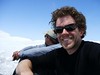
I had a very foreboding and nervous feeling about the climb all week long. I guess my instincts are right on still. We left Corvallis at 4pm after my shift at the bar was over on Saturday and headed towards the mountain. When I picked Kalin up he was still packing so I knew the likelihood something would be forgotten was high so I questioned him about all his gear. 
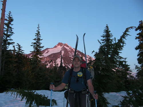
About 30 minutes into the drive on I-5 he remembered what he had forgot... his poles, an essential item for a climb on a cascade peak with skins and skis. So, after a few quick phone calls and gps navigation to a Big 5 sports store we were able to pick up some poles in Salem where I also grabbed some burgers at a fast food joint. We didn't make the trailhead until about 7:15 at night... I had hoped for 6pm at the latest.
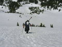
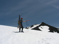
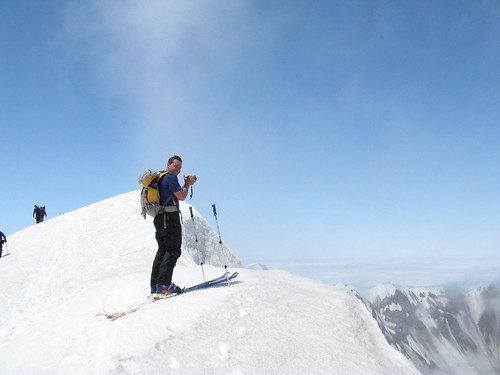
We started hiking with our very heavy packs full of overnight gear and climbing gear. Kalin had forgotten that his light weight rope was with a friend so we had to carry a heavier full-size rope for our glacier travel part of the climb and summit pinnacle. I would guess that my pack weighed close to 60lbs... no joke. It literally hurt my back to pick up and put on. This was not a good sign to begin with. After walking about a half mile up the snow-covered road to the trailhead 
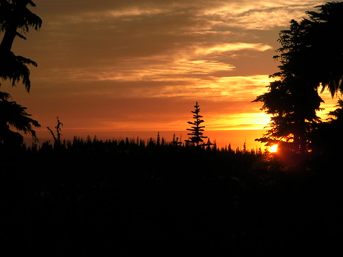
we started off and IMMEDIATELY lost all trace of the trail under 5' of snow cover still. The worst part was travelling through the trees which were melting out around the trunks creating ridges of narrow 
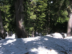
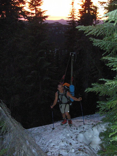
crusty snow between the trees that we were forced to walk on ski boots through, often falling into the tree wells and slipping with our very heavy packs on.
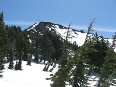
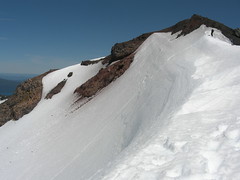
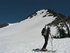
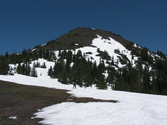
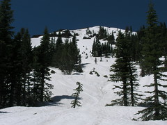
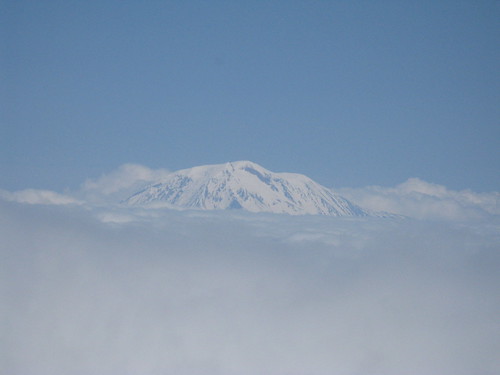
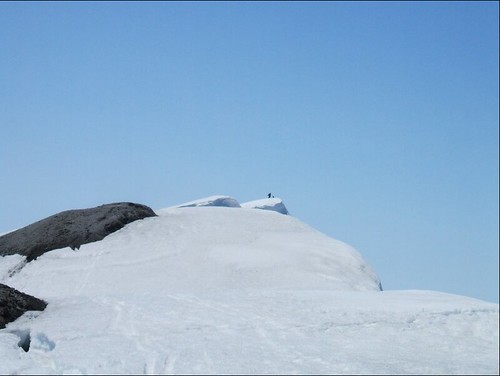
I quickly realized we were in the wrong drainage basin based on our GPS location so we climbed up onto Sentinal Hills Ridge and began hiking along the ridge hoping that the snow conditions through the trees would improve.... they did not. We found ourselves on multiple occasions on very steep slopes on the ridge trying to find the quickest and most efficient way to the base of the Jeff Park glacier but if felt as if we weren't making any forward progress on the ridge. Soon it was sunset which afforded us spectacular views of Jefferson in alpenglow and the sun setting over the hills to the west behind us. After the sun set it quickly began to darken and we were still a solid mile and half from where I wanted us to be positioned for the climb in the morning.

By 10pm both of us were quickly reaching the point of exhaustion and we had gotten sufficiently close to the col between Sentinal Hills Ridge and Jeff Park that I felt comfortable making camp. Sunday's forecast called for temps in the 90's on the glacier and possible thunderstorms after 11am so I decided to wake up at 3 am (we needed some sleep at least) and head out from there. As we fell asleep we could see flashes of heat lightning over the Sisters to the south and clouds in the valley below. In the middle of the night 
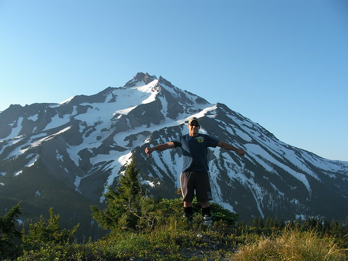
I woke up to a light shower of rain although all I could see above me was stars. It was very eerie and not a good sign.
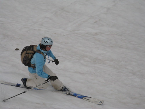
I slept intermittently and morning came way too quickly. We put on our headlamps and I made sure we had plenty of water for the days climb. The previous night I'd spent 20 minutes melting snow to make water for us. We were on the trail and hiking with lighter packs at 3:45am and yet we still were making incredibly slow progress through the trees on the ridge. When we finally reached the end of the ridge above the lakes at Jeff Park we realized with great clarity that making the summit just wasn't in the cards for the day. It was anguishing to turn around after such a great effort the night before to get as close to the glacier as possible with those terribly heavy packs but we just weren't going to make it. It would have been late in the day with the possibility of heat exhaustion, wet, mushy snow for traveling, a heavy rope, possibility of avalanches due to the heat, and on and on... Thus, Jefferson became the first Cascade Volcano that I've had to turn around on, a humbling experience for sure.

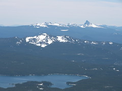
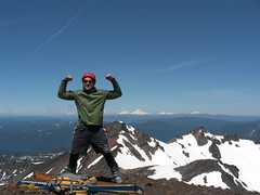
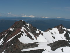
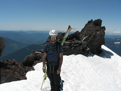
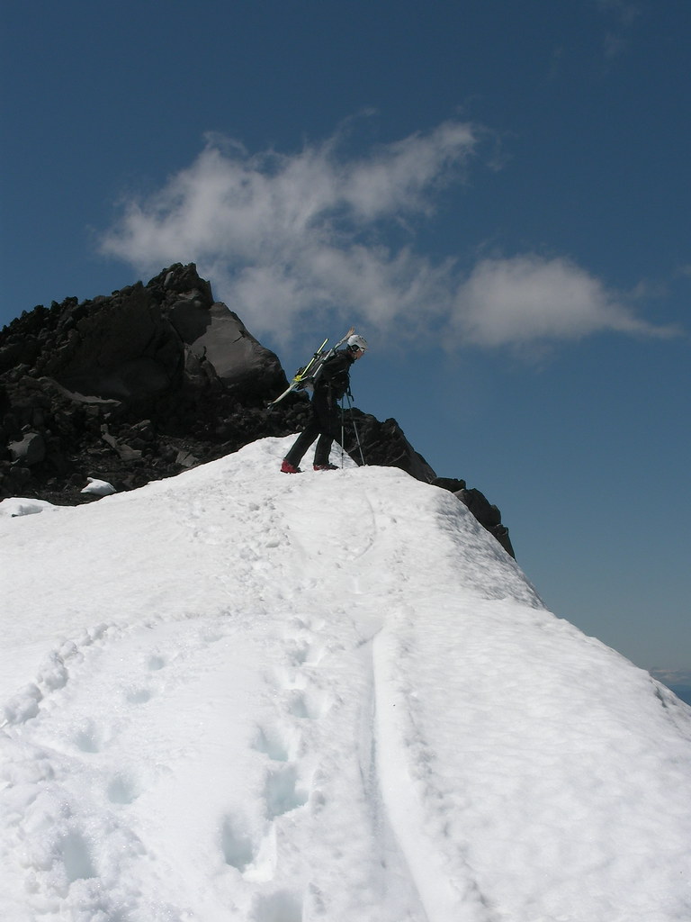
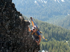
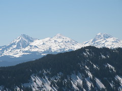
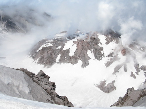
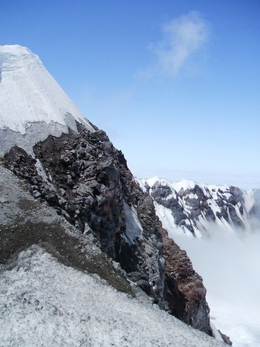
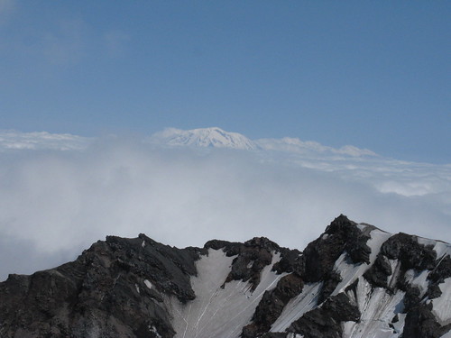
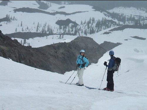
On the walk out we saw a great rock cliff on the side of Sentinal Hills and decided to climb it for some photos of the mountain and of Breitenbush River below in the valley. It was a great 
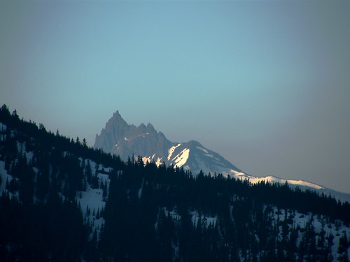
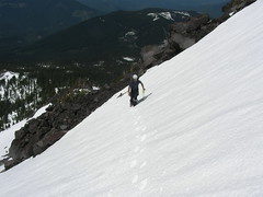
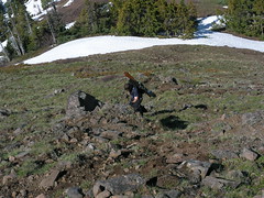
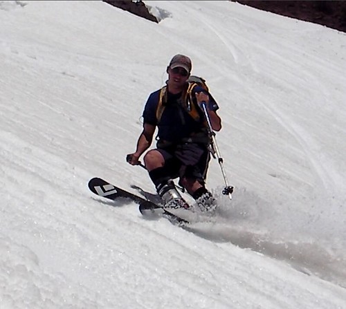
view and we had a really cool vantage point of Three Fingered Jack as well.

I can only describe the hike out AS THE MOST HORRIBLE EXPERIENCE in Oregon I've had to this date. My back hurt under the weight of the pack, I only was able to ski a 200 yard stretch of clear trail at one point and a little bit through the trees. The way we chose to get down was straightforward but horrible conditions for secure foot 
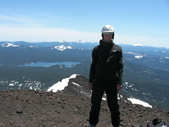
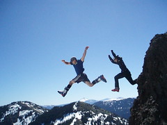
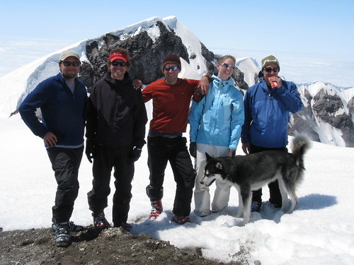
placement and we both fell multiple times. At one point I dislodged a bent over sapling from the winter which sprung up like a catapult hurling me through the air... all I could do was laugh... almost out of hysteria. I kept checking my gps to see how close the road was and reaching it was one of those great moments in life of relief that you won't soon forget.

We were back in Corvallis by 11am in the morning. Besides some great photos as you can see the whole experience sucked. Jason told me that Jefferson is the kind of difficult peak that you have to EARN and I guess he's right. Hopefully, after this humbling experience the mountain will allow me to climb it easier later in the year. This experience has taught me to always allow more time than needed and it has given me even more respect for the mountains that provide me so much joy in my life. Below is a GPS track of our route showing how close we got... click the title for all the pics. I'll be back!

Sunday, June 22, 2008

Diamond Peak & Epic BC Skiing

This weekend Hartz and decided to tackle Diamond Peak after hearing great things from Quin about his trip a few weeks before. I forwarded a link to Hartz of Quin's photos but refused to look at them myself as I wanted to be surprised on the mountain. I switched shifts with a friend at Ruby's so I could get out early on Saturday night allowing us to start driving to Diamond around 9pm so we could camp out at the trailhead overnight.

It was a beautiful drive through the Oregon woods to the trailhead road which we found covered with snow. My GPS said that we were only about 3 miles from the summit as the crow flies so we pulled over on the side of the road, pulled out some beers and chatted for a while before hittin' our sleeping bags around 2am. It was a beautiful night with a very bright moon that actually cast my shadow on the ground next to me. We saw a bunch of shooting stars and satellites and after contemplating life on other planets for an hour or so it felt good to finally curl up in my warm 0 degree Big Agnes bag. Unfortunately I didn't sleep very well because Hartz has a snoring issue and I had slept in late on Saturday morning to catch up on some much needed rest. 5am and the sun rising above us came all too quickly but Hartz was nice enough to wait until 6am to kick me in the head to wake me :)

After packing up in the morning and eating a Thai Satay backcountry pantry dinner for breakfast we headed up the road towards the trail to Corrigan lake. The road had patchy snow on it so we ended up walking and skinning off and on until we got to the trail which was suprisingly closer to where we had to leave the truck than I had expected it to be. What followed from there was a slog for several hours on skins and bootpacking through the woods towards Corrigan lake and then the treeline. There were a few mosquitos out which were annoying but not too bad. The snow in the woods had a lot of crap all over it fallen from the trees in the winter so our skins got really dirty and lost a bit of traction but we finally made it to treeline and they cleaned up fast on the clean snow above the trees.

Looking up at the lower peak we had to make a decision on which way to go. All our options looked incredibly steep except for a ridge of jagged rocks that looked safe but challenging to the southwest. We couldn't even see the Northwest ridge that we were trying to get to. If we had only hiked about 50 vertical feet higher we would have clearly seen the correct route off to the left but instead we decided to traverse to the south and climb up the ridge we saw. The sun was very hot as we boot-packed up the very steep bowl to the ridge and then made our way through the rocks. I took the lead stomping deep tracks for Hartz and I across the steep snow slopes where we used our ice axes for safety. Hartz correctly made the decision to climb to the top of the ridge instead of traversing to the true summit which we could see in the distance as soon as we topped the ridge. This was a great decision as it dumped us out onto a broad snowfield leading up to the summit. We saw two guys who had driven past us last night at 2am up on the summit. They looked like ants as the peak was still a good distance away.

As we began to climb the final summit ridge the two raced past us on tele skis past the saddle and then started hiking up the lower summit. We watched as they dropped into an incredibly steep bowl kicking up small wet slides as they went. When we got higher on the ridge we also noticed that one of them had skied down the 80 degree headwall at the top as well. Of course Hartz and I would have to up the ante on this one...

We reached the top around 1:30pm I think and took our time absorbing the sweeping views of all the surrounding cascades. To the south was Bailey, McLoughlin, and Crater Lake while to the North were Hood, Jefferson, The Sisters, Broken Top, Three-Fingered Jack and Bachelor Butte. All were clearly visible under bluebird skies. We signed some scraps of paper left in a tin can on the summit and chatted with a guy who we met who had come up a different route about his ski setup which was almost exactly the same as mine. I decided to walk down a little ways from the summit to film Hartz skiing the steep headwall. He made some sweet jump turns down it in perfect form as usual. I followed him and decided I wanted a little more airtime if possible. I moved over to skiers left 20 feet to a slightly steeper area, pointed em' and just at the top of the steepest part jumped to get about 15 feet or so of distance in the air over the snow.

We were so pumped when we got back down to the saddle to hike up the lower peak. As we were going up I took a few photos of Hartz looking over the edge of what we were about to ski and it looked impossibly steep. (See the picture of Hartz peering over the edge). I asked Hartz to film me this time from the top, clicked into my bindings, through on some music and jumped into it carving some big arcing turns around a crevasse and down the steep slope to the bottom of the Northeast Bowl on Diamond. It was one of the best backcountry runs I've ever experienced. The snow was perfect and FAST. On the way down I could see my wet slough following me as I jumped over and through the small slides set off by the tele skiers before us. At the bottom I had a great view of Hartz slayin' it down the slope and jumping off a cornice as well with his slough chasing him as well.

From the bottom of the bowl we put our skis back on our packs and trekked up to a saddle on the ridge following the steps of the skiers before us who were headed back to the same camp as us and from the style of their skiing and the routes they picked we could tell they had been there before and knew the best way. From the ridge we had a few more big open snow slopes to ski down and then ended up in the trees back to the trailhead road. It was rough heading down through the trees again as before the snow was littered with debris from the trees above... just gonna need to wax my skis again!

We passed the tele skiers through the woods on the way out as we followed a drainage down to the road. Once on the road it was a quick walk back to the truck where we picked up a couple beers we had buried in the snow when we woke up. It's always nice to have a cold beer waiting for ya after a tough climb and ski. The drive through the woods down the forest roads was beautiful and was great to finally see in the day time. We made it back to Corvegas in about 2 and half hours and actually used less gas then it takes me to get to Mt. Hood although our trip was a solid 2 hours longer round trip. Must be because of the lower driving speeds on the back roads. With gas prices as bad as they are this of course means that Diamond Peak is going to be a top choice for me for some great backcountry skiing all year round. I can't wait to go back!

As usual click the title for a great slideshow of all the great pictures from the day.

Saturday, June 14, 2008

Cone Peak Backcountry Skiing

Hartz, Jon Stevens, Chris Holm and I climbed up Cone Peak in Santiam Pass on Saturday. We had no idea of how much snow was left on the mountains in the pass but we hoped there was enough to get some turns on. Chris Holm had already packed up his gear thinking the season was over.. and it sure looked like it on our way up the Southwest Ridge of Cone Peak. We hiked through the open woods from the road below up to the open alpine meadows of Cone to find no snow! Chris and Jon were hiking in their downhill ski boots up the mountain in the dirt! Uh-oh. It was a quick climb and we had great views of Iron Mountain to the West and all the surrounding Cascades (Jefferson, Black Butte, The Sisters, Three Fingered Jack, and even Hood and Adams to the North). We got some great photos on a volcanic dike outcrop near the summit messing around. When we got to the top we found there was deep snow on the backside of the mountain for us to ski down, right from the summit. There was a big gap between the summit rocks and the start of the snow that was about 12-15 feet deep and about 15 feet across.... so I decided to jump it, and Hartz of course quickly followed my lead with Chris taking photos below. It was a lot of fun, and not to dangerous because the snow was soft and forgiving for our landing below in our ski boots.

We had a great descent of the backside of Cone Peak on some fun soft snow. When we got down we decided to hike back up to the ridge and consider skiing over to Iron Mountain to get some runs on it but it would have been a close call to get me to work on time that night so we decided to just head down, expecting to have to walk half the distance to the road due to the lack of snow. We climbed around to a southern facing snow field and climbed up it to the top to ski the whole thing. I was able to get a few big sweeping turns on it backwards and Jon Stevens set off a 40 foot wet slide about an inch thick that was entertaining to watch but not dangerous at all. When we got to the treeline we kept finding snow through the trees and pushed our luck on the decent. We had to cross a stream a few times to get to the remaining patches and then skied over a lot of pine needles and branches on the snow through the woods. All of a sudden I heard a truck in front of me, looked up and saw the road 40 feet ahead of us! I couldn't believe that we had actually managed to ski down the entire mountain to the road in mid June! Amazing.

Before leaving the pass I took the extra time we gained by skiing down to the road to show the guys the Sawyer Ice Cave in the pass. This time when we went in I wanted to check and see if it went deeper and it certainly did. I'm not sure how Emily and I missed it the first time we were in there. It was still very icey and there were plenty of icicles left hanging from the ceiling and coming up from the floor. All the guys were really impressed. The back cavern of the cave that we found was really cool. The floor was solidified molten lava. It looked like it must have flashed cooled. It wasn't the chunky lava rock of the dike we had climbed earlier on Cone Peak. The floor actually looked like solid liquid. Check the photos to see what I mean.

It was a beautiful day and it was nice to finally get some runs in with Jon Stevens. Definitely click the title of this entry for some amazing photos from the trip!

Sunday, June 1, 2008

Mt. St. Helens Ski Trip

After a week of planning, purchasing permits and watching the weather Quin, Ashley, Ben, Mike and I decided to attempt a ski descent of Mt. St. Helens via the Worm Flows route. Unfortunatley for us the road to the trailhead hadn't been plowed out this year because of lack of funds after such a harsh winter and high snowfall. This meant that we would have an additional 3 miles each way of skinning up the access road to the trailhead making the 12 mile hike an 18 mile trip. Permits were $22 bucks each for the mountain.
We all took off from my house on Saturday evening from my place after I got out of work bartending at 5pm. We stopped for pizza at a place called Mississippi Pizza in Portland. It started to rain while we were there which was not a good sign for our ascent on Sunday. The weather called for a 30% chance of rain in the morning and clearing in the afternoon around 3pm. We stopped at the Lone Fir resort to pick up our permits and stopped to get firewood as well (which we never ended up using). We drove up the road as far as we could before we hit snow blocking our path and pulled over to camp. After chatting for a bit and having some beers we all crashed at around midnight under a beautiful night sky of stars. I think we even saw an iridum flare.
We woke up at 5:45 and after some packing and breakfast we were on our way up the road in a thick morning fog. We made really quick progress up the road once we popped on our skis and skins, hopping onto a snowmobile trail to get to the treeline and the winter route up the volcano. Several snowmobilers passed us and we had to choke on their 3-stroke fumes for a little while. We quickly made the 3-4 mile skin to the treeline in about 1:45min. We then started skinning up the worm flows towards the summit in thick cloud cover, occasional showers, and heavy, hot humidity. I kept urging the group to ascend slowly as we were making great time and I wanted to give the weather a chance to clear out. As we climbed several rocks whipped by us on the snow as they dislodges from slopes above us. Quin's dog Jack chased each one of them down the slope regardless of his commands to stop until he was out of site, yet he always found his way back to us. As we passed 6800 ft the couple climbing with us started to ski down as they gave up on any views from the summit. This proved to be a poor choice for them because at about 7500 feet we broke through the clouds into beautiful blue skies.
The last push up the glacier to the crater rim was tiring and I was amazed to see Ashley taking the lead and blowing Quin and I away. Later I learned she is doing two 100mile bike rides every weekend and running 20+ miles on a regular basis to train for an Iron Man in Lake Placid, NY.... so I didn't feel so bad. Upon reaching the crater rim the clouds were pretty much all gone except for a huge plume of steam rising from the growing lava dome in the center of the 1980 crater. Standing on the edge of the rim was an amazing feeling. The crater had to be well over a mile in diameter. It really gave you a good sense of the massive energy involved in blowing the top 1300 feet of the volcano away. We were of course on snow the entire ascent and it was never so steep that we had to take our skins off but I've been told in the summer people often have to wear mouth shields due to the amount of ash and dust still on the slopes on dry days.
The overhanging cornices on the crater were immense. The last 20 to 30 feet of snow to the edge was all a cornice overhanging the crater. Where the cornice connected to the rock were cracks and fissures at it is slowly dislodging from the wall. We were very careful while traversing over this area as the entire thing could let go at any time and always stayed near the cracks so that we could lunge if we needed to. As the clouds started to clear we were afforded beautiful views of the surrounding volcanoes sticking up like islands in a sea of clouds (Hood to the south, Adams to the East, and Rainier to the North). The view over the steaming lava dome below north to Rainier was amazing. Where we emerged on the rim was still a quarter mile away from the true summit so Quin, Ashley and I took the extra 20 minutes to skin over to the true summit and "bag" the peak while Ben and Mike stayed back to take photos and wait for us. On the way over Jack decided to eat the lunch of a couple that was also on the top.. hehe. He also kept going very close to the edge of the cornice much to the dismay of all of us. Thankfully he never fell in. Ashley and I got some summit shots of us with Mt. Rainier behind us in our Mountaintech jackets (hoping for some points). We could clearly see down into crater from the true summit. We saw sulpher deposits, a ton of vents, growing fins of solidified lava, and the only glacier in the Northwest that is actually growing at a rate of 15ft of elevation per year inside the crater thanks to the shade of the crater walls. It really felt as if the mountain was alive underneath our feet.
We popped on our skis at the summit and started our descent on amazing snow. The snow was soft and forgiving and best of all, mostly trackless despite the 30+ other people supposedly climbing that weekend. On several occasions on the steeper slopes we set off very shallow slush slides about 30 feet wide which were fun to jump into and ski through as the slope was sliding around you. Jack ran by our sides the entire way down the worm flows back into the clouds below us. On the way down we all jumped cracks in the snow and jumped small crevasses as we came to them. It was a better descent than even Lassen earlier this spring. The views were fantastic (my lucky weather streak continues) and the skiing was fantastic.
When we got down to the road just before our cars we found the dumbass of the day. Some young kid had attempted to drive over the snow covered road to get closer to the trailhead... and got stuck in his Jeep Wrangler. Yes, we've all gotten stuck before but what makes him unique is that he had his overweight girlfriend with him, two young kids, bald tires, no chains, no snow shovel, no salt, and had broken his jack trying to jack the car for some reason off the snow.... yeah... a real winner. His girlfriend was using her flip-flop to scoop snow... So, all of us loaded up with shovels from the hike and back in the cars decided to dig him out. A few swift kicks from my AT boot quickly dislodged his broken jack uncer the car allowing the car to settle back down onto the wheels. Lucky for us some snowmobilers came along and pulled him out without us having to dig too much after a long day of skiing. Even while pulling him out backwards the kid almost steered the vehicle off the road again... unbelievable. After those shinanigans I was finally able to grab myself a beer from the car and celebrate with the others a highly successful and beautiful day of skiing.

That dot on the highest point in the last photo is me on the true summit. As always, click the title for a Flickr slideshow of all the photos! And make sure you have the "i" clicked so you can see descriptions of the photos.