 most glaciated peak in the lower 48 (behind Rainier). Because of the amount and size of the crevasses we would encounter on the route we needed to bring technical gear. I had bought ropes and
 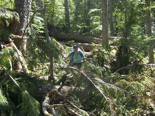 biners through my CMRU connection but unfortunately they didn't arrive in time so I was forced to buy another rope at REI on our way to the mountain along with some biners. I also took a belay device, some prusik links, a pulley, and two pickets to use for anchors if we needed to perform crevasse rescue.
 We left Corvallis around 3pm in the afternoon and after battling with Portland traffic and going to several REI's and a Safeway for dinner we got to the very busy trailhead for the Coleman Glacier Route around midnight on Friday. We camped out in the parking lot over night and got a start up the route at about 8:30 am. The route we were taking started around 3,700ft and 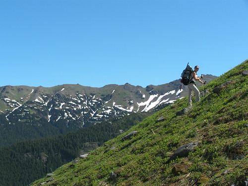 was 12 miles round trip. The three of us had overnight packs and my plan was to hike all day Saturday to get us as high as we could be on the Coleman Glacier for our Sunday morning summit attempt. This meant hiking up to 7,200 feet with our
 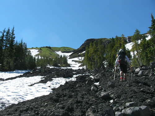 overnight packs, mine with skis strapped to it as well. Surprisingly though, my pack felt far lighter than it was on my attempt for Jefferson carrying the very heavy rope that Kalin had brought for us. This time I had the lightest weight 30m 8.1mm glacial-travel rope on the market so my pack felt considerably lighter.
was 12 miles round trip. The three of us had overnight packs and my plan was to hike all day Saturday to get us as high as we could be on the Coleman Glacier for our Sunday morning summit attempt. This meant hiking up to 7,200 feet with our overnight packs, mine with skis strapped to it as well. Surprisingly though, my pack felt far lighter than it was on my attempt for Jefferson carrying the very heavy rope that Kalin had brought for us. This time I had the lightest weight 30m 8.1mm glacial-travel rope on the market so my pack felt considerably lighter. Directly out of the parking lot we came to our first obstacle. The bridge over the stream had been destroyed and we had to walk a big log over the river. Imagine walking a round object in plastic ski mountaineering boots... it wasn't easy. We had to skirt a few blown down trees in the first mile or so until we came down to a  massively destroyed area. Any sign of the trail had been obliterated and we were forced to "bushwack through the downed branches and climb the downed trees for about 300 yards through the woods. It was difficult to say the least with big packs and Tiffany's bad shins... On the upside we passed by several beautiful waterfalls on the well maintained trail (except for the blow down areas) on our way to treeline.
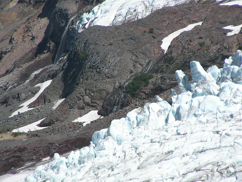
massively destroyed area. Any sign of the trail had been obliterated and we were forced to "bushwack through the downed branches and climb the downed trees for about 300 yards through the woods. It was difficult to say the least with big packs and Tiffany's bad shins... On the upside we passed by several beautiful waterfalls on the well maintained trail (except for the blow down areas) on our way to treeline. Once above treeline we found ourselves on patchy snow fields and a beautiful ridge covered in wildflowers with Baker towering behind covered in massive glaciers. It was truly a really beautiful sight. We took our time and enjoyed the astounding views to the North of the Coastal Range mountains of British Columbia. They were very jagged peaks and there were many of them. It was a very different view then the few cone shaped volcanoes springing out of the land back around Corvallis.
We made 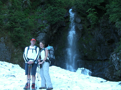 great time up the route and onto the bottom of the Coleman glacier were it spills over a cirque into the valley below. The weather was perfect with a cool breeze and about 70 degrees. Great temp for hiking without sweating too much in the sun reflecting off the ice around us. We made it to our camp below Heliotrope ridge at 7,200ft by around 2pm I think. We then had all afternoon to take a nap in the sun, set up our campsite, check out the views and practice crevasse self rescue. We even had views to the Puget Sound north of Seattle. I took off my shirt for a bit to try to even out my ridiculous farmer's tan but only managed to fall asleep and burn myself instead (I found this out today). We spent about an hour playing with my new gear and trying different variations of a Z-system to pull someone out of a crevasse if they fall in. I wished I had received all the gear I had ordered because we
 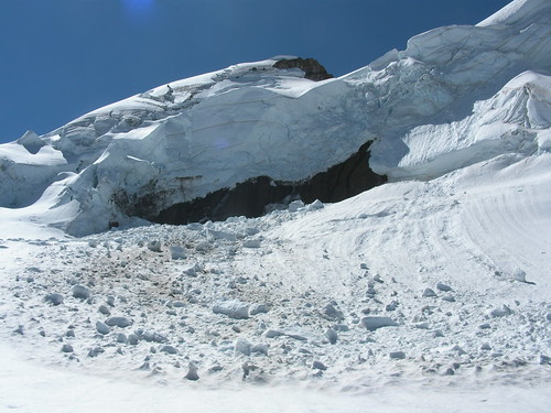 were lacking a few pulley biners to really try some stuff out I was curious about.
great time up the route and onto the bottom of the Coleman glacier were it spills over a cirque into the valley below. The weather was perfect with a cool breeze and about 70 degrees. Great temp for hiking without sweating too much in the sun reflecting off the ice around us. We made it to our camp below Heliotrope ridge at 7,200ft by around 2pm I think. We then had all afternoon to take a nap in the sun, set up our campsite, check out the views and practice crevasse self rescue. We even had views to the Puget Sound north of Seattle. I took off my shirt for a bit to try to even out my ridiculous farmer's tan but only managed to fall asleep and burn myself instead (I found this out today). We spent about an hour playing with my new gear and trying different variations of a Z-system to pull someone out of a crevasse if they fall in. I wished I had received all the gear I had ordered because we were lacking a few pulley biners to really try some stuff out I was curious about. Around 7pm I took out my jetboil and started melting snow for all three of us as well as boiling water for all of our meals. Miraculously the tiny jetboil fuel canister lasted over an hour and filled each of our camelbaks up before dying on our last nalgene I was filling full of water. We attempted to use my steripen once again to sterilize the water but that piece of equipment is not reliable and I frankly don't trust it much (I have to write them about my dissapointment). We all fell asleep under a beautiful sunset to the northwest of us. Tiffany was a bit cold over the whole night because her sleeping pad had come apart looking like a giant balloon instead of a flat mattress and rendering itself unsleepable inflated. She didn't get over an hour sleep all night, but thankfully she had Chris to cuddle up with the stay warm.
At 4am we awoke for a summit attempt. I didn't want to be any earlier because I wanted to snow to soften for my ski descent and I wanted there to be light while we traversed around the massive 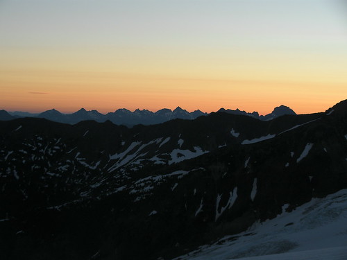 crevasses of the coleman glacier. By 5am we had packed up and were leaving
  camp roped up to each other with Chris in the middle and Tiff taking up the back end of our team with about 30-35 feet of rope between each of us. Ice axes out and helmets on we started up the glacier under a beautiful dawn to the east lighting up the jagged peaks to the north in Canada. We were the highest group camped on the mountain but several groups had started earlier than us so we just followed everyone up the very clear trail of footprints up the glacier. We passed by gaping crevasses and crossed several snow bridges. On one snow bridge I clearly saw a footprint dissapear into it with blackness beneath. It was really amazing being on such a beautiful mountain.
crevasses of the coleman glacier. By 5am we had packed up and were leaving camp roped up to each other with Chris in the middle and Tiff taking up the back end of our team with about 30-35 feet of rope between each of us. Ice axes out and helmets on we started up the glacier under a beautiful dawn to the east lighting up the jagged peaks to the north in Canada. We were the highest group camped on the mountain but several groups had started earlier than us so we just followed everyone up the very clear trail of footprints up the glacier. We passed by gaping crevasses and crossed several snow bridges. On one snow bridge I clearly saw a footprint dissapear into it with blackness beneath. It was really amazing being on such a beautiful mountain. I quickly discovered that without my usual hiking poles in hand I was A LOT weaker than I usually am. I had no idea how much those poles help me when I climb! Unfortunately for 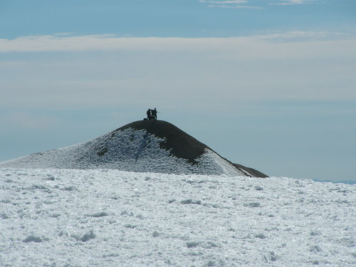 me Chris and Tiff are in great shape and bike often after work.
 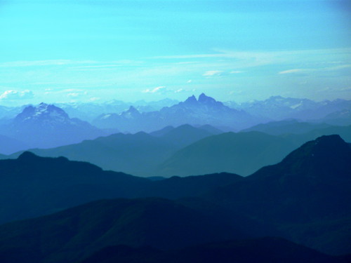 I on the other hand have two jobs and sit at a desk all day so I was by far the one out of shape on this climb. We made our way up the mountain and to the pass between Grant Peak (the true summit) and Colfax Peak. The pass is called the Coleman-Demming Saddle because it separates the two massive glaciers. From there it was up the very steep Roman wall to the summit. On the way up I was getting a little nervous because we were on boiler-plate ice... not good for skiing down. My legs were on fire by the time we reached the broad summit dome and headed over to the true summit (a tiny mound in the distance with people on top). It was extremely windy and cold on the summit so we didn't stay long. Tiff and Chris both headed down from the top out of the wind while I took a quick video and signed the register.
me Chris and Tiff are in great shape and bike often after work. I on the other hand have two jobs and sit at a desk all day so I was by far the one out of shape on this climb. We made our way up the mountain and to the pass between Grant Peak (the true summit) and Colfax Peak. The pass is called the Coleman-Demming Saddle because it separates the two massive glaciers. From there it was up the very steep Roman wall to the summit. On the way up I was getting a little nervous because we were on boiler-plate ice... not good for skiing down. My legs were on fire by the time we reached the broad summit dome and headed over to the true summit (a tiny mound in the distance with people on top). It was extremely windy and cold on the summit so we didn't stay long. Tiff and Chris both headed down from the top out of the wind while I took a quick video and signed the register. When we got back to the top of the summit dome I put on my skis, changed batteries in  my camera and
 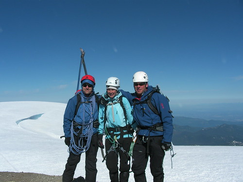 GPS and we all headed down from the top. It was extremely steep on the Roman wall for me and I was skiing on very hard rime ice (imagine holding a jackhammer to the bottom of your ski boots). At one point I needed to straight line through some rocks and the make a hard stop on ice above a very steep slope leading to crevasses below. It was challenging to say the least. I had been told by one climber on the way up that it wasn't skiable... I was set on proving him wrong and skiing as far down as I could from the summit.
my camera and GPS and we all headed down from the top. It was extremely steep on the Roman wall for me and I was skiing on very hard rime ice (imagine holding a jackhammer to the bottom of your ski boots). At one point I needed to straight line through some rocks and the make a hard stop on ice above a very steep slope leading to crevasses below. It was challenging to say the least. I had been told by one climber on the way up that it wasn't skiable... I was set on proving him wrong and skiing as far down as I could from the summit. Once back at the saddle the sun had been out long enough to soften the snow a bit which 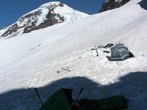 made for much better skiing. Tiff and Chris were both jealous they didn't have skis with them as well. I let
 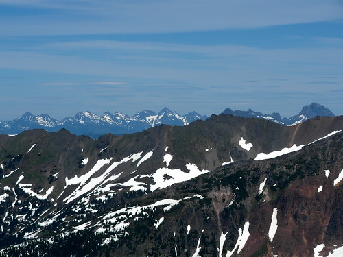 them travel ahead then began picking my line through the crevasses to either side of them, jumping some very deep ones occasionally to meet back up with them on the trail. They remained roped up but I was off rope on my skis. The bigger surface area and speed I was moving at down the slope actually made traveling on skis pretty safe over the crevasse fields. We had summited around 9:45am and were back down to camp and packed up by 1pm. I had an amazing ski descent down from camp all the way to treeline, only taking one stop to grab more water for Chris at the main campsite area below the Coleman Glacier. Chris and Tiff got a one really fast ride on their butts for about a quarter mile down the glacier at one point, picking up a lot of speed on their way and later down the mountain I got a great video of them glisading down a steep slope as well.
made for much better skiing. Tiff and Chris were both jealous they didn't have skis with them as well. I let them travel ahead then began picking my line through the crevasses to either side of them, jumping some very deep ones occasionally to meet back up with them on the trail. They remained roped up but I was off rope on my skis. The bigger surface area and speed I was moving at down the slope actually made traveling on skis pretty safe over the crevasse fields. We had summited around 9:45am and were back down to camp and packed up by 1pm. I had an amazing ski descent down from camp all the way to treeline, only taking one stop to grab more water for Chris at the main campsite area below the Coleman Glacier. Chris and Tiff got a one really fast ride on their butts for about a quarter mile down the glacier at one point, picking up a lot of speed on their way and later down the mountain I got a great video of them glisading down a steep slope as well. Heading 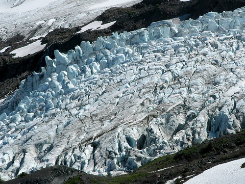 back through the woods was long and tiring on my sore feet and negotiating
  that blowdown again sucked. I had met two forest service workers hanging out at our camp hours ago and began to wonder why they were way up the glacier instead of helping to clear the trail in the woods below. But, we got through and ended up reaching the car around 3:30pm. My ankles had blisters half the size of dollar bills on each of them so it was heaven to put my flip flops back on. The ride home was long and tiring but between Tiff and Chris driving we made it! He even averaged 37mpg in his Subaru for some amazing reason!
back through the woods was long and tiring on my sore feet and negotiating that blowdown again sucked. I had met two forest service workers hanging out at our camp hours ago and began to wonder why they were way up the glacier instead of helping to clear the trail in the woods below. But, we got through and ended up reaching the car around 3:30pm. My ankles had blisters half the size of dollar bills on each of them so it was heaven to put my flip flops back on. The ride home was long and tiring but between Tiff and Chris driving we made it! He even averaged 37mpg in his Subaru for some amazing reason! It 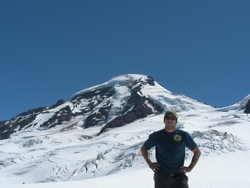 was truly an amazing climb and ski descent from me. After completing this climb I have now climbed and skied from the tops of both the southern most U.S. Cascade Volcano (Lassen in California) and now the Northernmost Cascade volcano (Baker in Washington) both in the same spring/summer. I'm super stoked and looking forward to Rainier in a few weeks.
was truly an amazing climb and ski descent from me. After completing this climb I have now climbed and skied from the tops of both the southern most U.S. Cascade Volcano (Lassen in California) and now the Northernmost Cascade volcano (Baker in Washington) both in the same spring/summer. I'm super stoked and looking forward to Rainier in a few weeks. I got some really great photos from this climb that I've posted on Flickr so I highly suggest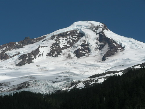 sitting back in a chair and watching the slideshow with descriptions by clicking the title of this blog entry in red above. The photo with the wall of ice shows a wall that is over 100 feet high crumbling onto the snow below. And also, compare the colors of our campsite during the day and then at sunset... Enjoy!
EveryTrail - Find the best hikes in California and beyond
sitting back in a chair and watching the slideshow with descriptions by clicking the title of this blog entry in red above. The photo with the wall of ice shows a wall that is over 100 feet high crumbling onto the snow below. And also, compare the colors of our campsite during the day and then at sunset... Enjoy!Mt. Baker
EveryTrail - Find the best hikes in California and beyond
No comments:
Post a Comment