Mount Jefferson Successful Summit
 After Chris and I had failed at summiting Mt. Jefferson in June on a ski descent with Dan I had told our friend Garrett that we would be trying for the summit again in August. We had gotten to within 25 feet of the top but with ski boots on and in cold 30mph winds it would have been an extremely dangerous call to go for it so we had turned around which turned out to be the wise decision as it instantly became a whiteout situation on the mountain for the ski descent (read earlier post).
 This time around we would be going in as a day hike with super light packs and minimal gear for the summer ascent. Garrett had been waiting to climb this mountain for 6 years as I had and I wasn’t about to let another summer go by without getting to the true summit. I was nervous about the top as it would require a rappel and possible belay on the climb up so I had asked a girl named Beth at work to go with us who was a regular rock climber at Yosemite.

 Unfortunately, Beth got fired and thus completely bailed on the climb us leaving Holm, Garrett and I to find a way ourselves to the top. I did a lot of research online as to the best route and the possibility of a scramble to the top without ropes and it seemed feasible. The only difficult part was a 50 degree snow field that we would have to traverse under the summit block but I was hoping that it would be late enough in the season that it would be rock instead of ice. Chris also managed to score some strong rope material from his job that we could leave at the top after our rappel off the summit. So.. we were good to go!
 After a late drive from Ridgefield on Friday night to the trailhead I met up with Garrett and Chris who had come from Corvallis and had just gotten there before me. It was 10:30pm and we were getting up at 3:30am for the ascent so we quickly had a beer together and headed to bed right away. When my alarm went off at 3:15 am I headed over to Holm’s car and Garrett’s sleeping bag to wake them up.
 We hurriedly ate some quick breakfast and I helped Garrett figure out his gear.... because he had wayyy too much of it. He had brought heavy plastic mountaineering boots and massive steel crampons to snap onto them. He also had sneakers and a pair of boots. His pack would easily be twice the weight of mine if he packed all that stuff so I told him to just leave his crampons and plastic boots. Chris gave me questioning look but I found out Garrett had the same size boot as I did so if it came down to it I would just give him my crampons and boots if need be.
 We started down the trail in the pitch dark of nigh with our headlamps on towards Pamelia Lake. I had scored permits for this area as it was a high traffic area with only so many people allowed in at a time during high travel season. When we got to the lake Garrett stashed some beers in the cool water and left a small pack of gear for his wife Cassie would be setting up camp for them there later in day. We continued on through the dark gaining altitude along the PCT in the dark towards a small group of alpine lakes where we would head off on the climbers trail up the standard South Ridge route. Going this way added a few extra miles but from everything I read it was the least technical ascent and had the best trail to follow.
 When we got to the lake Garrett and Chris pumped some water for the day as we didn’t expect to find any high up on the mountain. It had been a really dry summer and I was surprised to see how low the water level of the lake was. It was 8am and the sun had been up for just over an hour. We had been on the trail for 4 hours now and were about to start our serious ascent of the formidable mountain.
 At the start of the ascent we found ourselves heading up through grassy meadows surrounded by ridges of tall pines with Jefferson towering above us to the north. I was following a GPS track on my GPS that I had downloaded from the Santiam Alpine Club. This was very helpful as it gave me a clue as to when to cut right and uphill to gain the south ridge just above Goat Peak. We gained the ridge around 9:30 in the morning and from there on up it was exactly as others had described it... a long arduous trudge up loose volcanic rock. We had fantastic views looking south towards Three Fingered Jack, Mt. Washington and the Sisters the entire way up. We even passed through what appeared to be a volcanic dike on the ridge.
 We broke out above the tree line on the ridge just around 10:30 with the ridge itself becoming a lot steeper. We also found ourselves crossing snowfields and then alongside the Waldo Glacier where we spotted something orange in the snow. This freaked us out at first because at the trailhead we had seen a photo of a man that had been missing on the mountain since Thursday and the first thing that popped into our heads was “body”. Thankfully, when Chris went over to check it out it turned out to be the remains of a weather balloon.
 We continued upward on the ridge that seemed to go on forever. The rocks were a mixture of large 1-5 foot wide boulders to light pumice that slipped downhill with every step. With every step our feet would slide downhill half a step in the loose rock which added to our exhaustion. Gradually, the Waldo Glacier became a small patch underneath us and we approached the Red Saddle at about 10,000 feet. To get to the saddle we had to scale a pretty tall tower of rocks that involved hand and feet scrambling. This wasn’t even noted in the guidebook so it had me a little worried about what we would encounter beyond this. The altitude and the fact that we had already been hiking for 9 hours non-stop led to us being pretty beat at this point.
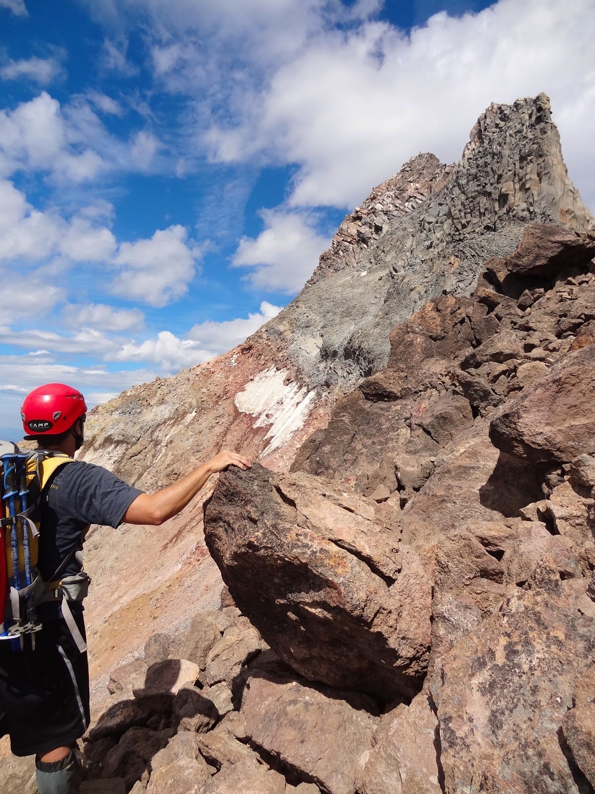
 The Red Saddle was actually a very colorful and beautiful area on high up on the peak. From it we could look down the west face of the peak and it looked very different from when we were here last and it was covered in snow. Towering above us was the south horn of the summit. We would have to traverse across the 50 degree snowfield here to get to the north horn to climb to the top.
 Thankfully, the snowfield was very small this late in the season as I had hoped and we were able to down climb and then traverse underneath it. It was definitely still scary as we would watch every small rock we kicked loose tumble down the face of the mountain. It was definitely not a place to fall or loose your grip. For fun I had Garrett dislodge a 50-75lb boulder so we could watch it rocket down the face of the mountain.
 When we arrived at the base of the north horn I had pretty good idea of the zig zag route we would take up it and Chris took the lead with Garrett in the middle so I could direct from below with a better view of where to go. Chris took his time but Garrett just rocketed up the scramble after him like it nothing at all. Obviously, Garrett is a beast and clearly wanted the summit. The scramble to the top turned out to be pretty easy so long as you didn’t look down or think about the exposure and we chose not to worry about roping up as there weren’t many places to place protection anyway. The rock was pretty secure on the way up but we were still careful to check every hold before pulling ourselves up further.
 The summit was amazing. There was just enough room for the three of us to sit among the summit rocks and gaze out over the surrounding Cascade Peaks. To the north in a lot of fire haze we could make out the outline of Hood and to the south we could see all the way to Diamond Peak. Below us on the northeast side of Jefferson was the Massive Waterfall 2 fire that had spread to about 30,000 acres and was still smoking about 5 miles from where we were. It looked small from so high up on the mountain. We found a summit register and signed in and I set up the gorilla pod to snap some photos of us on the summit.
 Chris and I could see exactly how close we had been in June from the summit but were happy we had made the right call not to push it as the exposure on the east face of the peak was just nuts. It seemed like the mountain just dropped away under my feet all the way down to the broad Whitewater Glacier. It had taken us 10.5 hours to get to the summit and we didn’t take much time to hang out there as I was worried about getting off the ridge by dark. Chris found a secure summit rock that was perfect for looping his work rope around (the one Garrett is licking) to use as our anchor for our first rappel rope length. I pointed out to Garrett the holes with what looked like black tar coming out of them and explained that they were the result of lightning strikes on the summit of the peak.
 We had put our harnesses and helmets on at the Red Saddle for the final ascent so after Chris and I flaked out the rope over the edge we hooked up and began our rappel. Garrett asked to go 2nd with Chris taking the lead to straighten out the rope on the way down. Chris had made the rope loops himself at work but I decided to loop some other regular climbing rope around another rock as a backup for the rappel. Unfortunately, for me I was the last to go so I cleaned up the backup and just relied on Chris’ creation. If that doesn’t show trust for my best man I don’t know what does. I checked to make sure Garrett had his harness on correctly and was clipped in ok with his atc guide belay device. I reminded him of a few things when rapelling and how to hold the rope and he was off with me watching the anchor and getting some video of him heading down. I followed and we began to set up our 2nd and last rope length down to the base of the summit block.
 Our second rappel was a bit more sketchy as we had a lot of difficulty locating a good anchor point. Chris found the edge of a big rock and the looped the rope from work through a crack as well. I took a nut we had borrowed from Jason and secured a backup line again for his rope and attached an old figure 8 I had to it that I would leave up there as there would be no way to retrieve it once I was down. This time when Chris started down I noticed his work rope fraying a little bit in the sharp crack he had looped it through, which is not typical of climbing rope. It wasn’t fraying dangerously but it definitely would not be a long lasting rope for years, and thus good that we just left it up there. Hopefully other climbers will know better than to rely on it for a safe descent in the future. Once Garrett was down again I cleaned up the backup (but forgot to grab Jason’s #11 nut) and headed down. My 2nd rappel was a bit less sloppy than my first rappel.
 Once off the summit block we packed up my rope and headed back over the 50 degree snow field to the red saddle again where we took a little breather to collect ourselves after the danger of the summit ascent. It was now 4pm. This only left us about 3.5 hours to make it down the ridge and this made me nervous as we were now at 12+ hours of climbing and Chris and Garrett were out of water and all of us were exhausted. Looking at our options Garrett made the call that he wanted to try heading down the SW ridge to shave off time and distance from going down the way we had come. I had reservations about this as I knew the SW ridge was steeper and we knew what to expect on the South Ridge but I agreed to it and I took the lead down to keep us moving along.
 At first the descent was actually kind of fun as we were literally skiing down through the loose rock. We took lines straight down faces of loose scree that we sunk about 6 inches deep into with each step. Garrett jumped ahead of me and we made fantastic time down to the top of the SW ridge just an hour later. On the ridge I again took the lead to hustle us down and I quickly found that due to the steepness it would be much slower going.
 About half way down the ridge we met two guys who had climbed up it off the climbers path and told us to just stick to the ridge crest. I did so, but after another 20 minutes of scrambling around really technical sections of rock I decided it was too late in the day and we were too tired to keep going at that rate so I made the call to ski down a big scree field to the valley below and just head through the woods back to the PCT.
 I had hoped for open woods back to the PCT but instead go the exact opposite. What followed was nearly two hours of the worst descent from a peak I’d ever had. We found ourselves in very steep terrain that was completely overgrown with rhododendron bushes that were about 3-6 feet in height that we literally had to just fall down the hill through. In desperation I tried to traverse right back to the ridge to look for the climbers trail lower down but had absolutely no luck.
 At one point I found boot tracks but they didn’t seem to lead anywhere. It seemed to take us forever to descend that 2,000 feet through absolute hell. It nearly broke all our spirits completely. Apparently, Jefferson let us summit but it wasn’t about to let us out easily. Chris and I are usually pretty level headed in extreme situations like this but after falling and tripping probably 50+ times on the way down I heard a bit of rage from Holm that I never really hear.. the mountain was beating him.
 When we finally stumbled our way out of the woods back to the PCT I knelt down and kissed the trail in absolute Joy. It was another 3 miles or so along the trail back to Pamelia Lake and water and all of us were extremely dehydrated but it felt like heaven to be on a clear path again. We stumbled down the trail with my legs shakier than they’ve ever been. I was dying for water and could almost smell it. If I was that thirsty I can’t imagine what Chris felt like. We only walked about a half mile before we had to put on our headlamps to see the way. We had barely made it off the ridge and out of the woods in time!
 Back at Pamelia Lake we met up with Cassie who had set up camp for Garrett. I figured Emily was probably panicked at this point so I downed a camelbak Cassie had and booked it out of the woods in the dark. On the way out alone I was constantly aware of the story Dan had told us about Cougers being along that trail. It didn’t take me too long to travel the 2.5 miles back out to the truck but when I got there I was so exhausted I forgot to step on the clutch to start the truck and thought for a brief moment my battery had died = spirit broken. Fortunately, I regained my wits and started the truck up for the drive out but about 10 minutes later the cooler of beer in my backseat spilled and killed the amp under my passenger seat forcing me to shut off the radio for the entire 2.5 hour drive back to Ridgefield. We hadn’t even stopped to drink a beer that Garrett had stashed at the lake for us on the return.
 I made it back to Ridgefield by about 11:30pm and simply passed out from exhaustion, so happy to sleep in the next day and relax after one of the hardest ascents of my life. Stats for the hike were 19.2 miles, 17 hours of non-stop hiking and nearly 8,000 feet of climbing. This was a hike that most people do in 3 days and we did it in 17 hours. I think we had definitely proven ourselves on this trip. Beautiful views at the top but I have no intention of climbing it again anytime soon!

 After Chris and I had failed at summiting Mt. Jefferson in June on a ski descent with Dan I had told our friend Garrett that we would be trying for the summit again in August. We had gotten to within 25 feet of the top but with ski boots on and in cold 30mph winds it would have been an extremely dangerous call to go for it so we had turned around which turned out to be the wise decision as it instantly became a whiteout situation on the mountain for the ski descent (read earlier post).
 This time around we would be going in as a day hike with super light packs and minimal gear for the summer ascent. Garrett had been waiting to climb this mountain for 6 years as I had and I wasn’t about to let another summer go by without getting to the true summit. I was nervous about the top as it would require a rappel and possible belay on the climb up so I had asked a girl named Beth at work to go with us who was a regular rock climber at Yosemite.
 Unfortunately, Beth got fired and thus completely bailed on the climb us leaving Holm, Garrett and I to find a way ourselves to the top. I did a lot of research online as to the best route and the possibility of a scramble to the top without ropes and it seemed feasible. The only difficult part was a 50 degree snow field that we would have to traverse under the summit block but I was hoping that it would be late enough in the season that it would be rock instead of ice. Chris also managed to score some strong rope material from his job that we could leave at the top after our rappel off the summit. So.. we were good to go!
 After a late drive from Ridgefield on Friday night to the trailhead I met up with Garrett and Chris who had come from Corvallis and had just gotten there before me. It was 10:30pm and we were getting up at 3:30am for the ascent so we quickly had a beer together and headed to bed right away. When my alarm went off at 3:15 am I headed over to Holm’s car and Garrett’s sleeping bag to wake them up.
 We hurriedly ate some quick breakfast and I helped Garrett figure out his gear.... because he had wayyy too much of it. He had brought heavy plastic mountaineering boots and massive steel crampons to snap onto them. He also had sneakers and a pair of boots. His pack would easily be twice the weight of mine if he packed all that stuff so I told him to just leave his crampons and plastic boots. Chris gave me questioning look but I found out Garrett had the same size boot as I did so if it came down to it I would just give him my crampons and boots if need be.
 We started down the trail in the pitch dark of nigh with our headlamps on towards Pamelia Lake. I had scored permits for this area as it was a high traffic area with only so many people allowed in at a time during high travel season. When we got to the lake Garrett stashed some beers in the cool water and left a small pack of gear for his wife Cassie would be setting up camp for them there later in day. We continued on through the dark gaining altitude along the PCT in the dark towards a small group of alpine lakes where we would head off on the climbers trail up the standard South Ridge route. Going this way added a few extra miles but from everything I read it was the least technical ascent and had the best trail to follow.
 When we got to the lake Garrett and Chris pumped some water for the day as we didn’t expect to find any high up on the mountain. It had been a really dry summer and I was surprised to see how low the water level of the lake was. It was 8am and the sun had been up for just over an hour. We had been on the trail for 4 hours now and were about to start our serious ascent of the formidable mountain.
 At the start of the ascent we found ourselves heading up through grassy meadows surrounded by ridges of tall pines with Jefferson towering above us to the north. I was following a GPS track on my GPS that I had downloaded from the Santiam Alpine Club. This was very helpful as it gave me a clue as to when to cut right and uphill to gain the south ridge just above Goat Peak. We gained the ridge around 9:30 in the morning and from there on up it was exactly as others had described it... a long arduous trudge up loose volcanic rock. We had fantastic views looking south towards Three Fingered Jack, Mt. Washington and the Sisters the entire way up. We even passed through what appeared to be a volcanic dike on the ridge.
 We broke out above the tree line on the ridge just around 10:30 with the ridge itself becoming a lot steeper. We also found ourselves crossing snowfields and then alongside the Waldo Glacier where we spotted something orange in the snow. This freaked us out at first because at the trailhead we had seen a photo of a man that had been missing on the mountain since Thursday and the first thing that popped into our heads was “body”. Thankfully, when Chris went over to check it out it turned out to be the remains of a weather balloon.
 We continued upward on the ridge that seemed to go on forever. The rocks were a mixture of large 1-5 foot wide boulders to light pumice that slipped downhill with every step. With every step our feet would slide downhill half a step in the loose rock which added to our exhaustion. Gradually, the Waldo Glacier became a small patch underneath us and we approached the Red Saddle at about 10,000 feet. To get to the saddle we had to scale a pretty tall tower of rocks that involved hand and feet scrambling. This wasn’t even noted in the guidebook so it had me a little worried about what we would encounter beyond this. The altitude and the fact that we had already been hiking for 9 hours non-stop led to us being pretty beat at this point.
 The Red Saddle was actually a very colorful and beautiful area on high up on the peak. From it we could look down the west face of the peak and it looked very different from when we were here last and it was covered in snow. Towering above us was the south horn of the summit. We would have to traverse across the 50 degree snowfield here to get to the north horn to climb to the top.
 Thankfully, the snowfield was very small this late in the season as I had hoped and we were able to down climb and then traverse underneath it. It was definitely still scary as we would watch every small rock we kicked loose tumble down the face of the mountain. It was definitely not a place to fall or loose your grip. For fun I had Garrett dislodge a 50-75lb boulder so we could watch it rocket down the face of the mountain.
 When we arrived at the base of the north horn I had pretty good idea of the zig zag route we would take up it and Chris took the lead with Garrett in the middle so I could direct from below with a better view of where to go. Chris took his time but Garrett just rocketed up the scramble after him like it nothing at all. Obviously, Garrett is a beast and clearly wanted the summit. The scramble to the top turned out to be pretty easy so long as you didn’t look down or think about the exposure and we chose not to worry about roping up as there weren’t many places to place protection anyway. The rock was pretty secure on the way up but we were still careful to check every hold before pulling ourselves up further.
 The summit was amazing. There was just enough room for the three of us to sit among the summit rocks and gaze out over the surrounding Cascade Peaks. To the north in a lot of fire haze we could make out the outline of Hood and to the south we could see all the way to Diamond Peak. Below us on the northeast side of Jefferson was the Massive Waterfall 2 fire that had spread to about 30,000 acres and was still smoking about 5 miles from where we were. It looked small from so high up on the mountain. We found a summit register and signed in and I set up the gorilla pod to snap some photos of us on the summit.
 Chris and I could see exactly how close we had been in June from the summit but were happy we had made the right call not to push it as the exposure on the east face of the peak was just nuts. It seemed like the mountain just dropped away under my feet all the way down to the broad Whitewater Glacier. It had taken us 10.5 hours to get to the summit and we didn’t take much time to hang out there as I was worried about getting off the ridge by dark. Chris found a secure summit rock that was perfect for looping his work rope around (the one Garrett is licking) to use as our anchor for our first rappel rope length. I pointed out to Garrett the holes with what looked like black tar coming out of them and explained that they were the result of lightning strikes on the summit of the peak.
 We had put our harnesses and helmets on at the Red Saddle for the final ascent so after Chris and I flaked out the rope over the edge we hooked up and began our rappel. Garrett asked to go 2nd with Chris taking the lead to straighten out the rope on the way down. Chris had made the rope loops himself at work but I decided to loop some other regular climbing rope around another rock as a backup for the rappel. Unfortunately, for me I was the last to go so I cleaned up the backup and just relied on Chris’ creation. If that doesn’t show trust for my best man I don’t know what does. I checked to make sure Garrett had his harness on correctly and was clipped in ok with his atc guide belay device. I reminded him of a few things when rapelling and how to hold the rope and he was off with me watching the anchor and getting some video of him heading down. I followed and we began to set up our 2nd and last rope length down to the base of the summit block.
 Our second rappel was a bit more sketchy as we had a lot of difficulty locating a good anchor point. Chris found the edge of a big rock and the looped the rope from work through a crack as well. I took a nut we had borrowed from Jason and secured a backup line again for his rope and attached an old figure 8 I had to it that I would leave up there as there would be no way to retrieve it once I was down. This time when Chris started down I noticed his work rope fraying a little bit in the sharp crack he had looped it through, which is not typical of climbing rope. It wasn’t fraying dangerously but it definitely would not be a long lasting rope for years, and thus good that we just left it up there. Hopefully other climbers will know better than to rely on it for a safe descent in the future. Once Garrett was down again I cleaned up the backup (but forgot to grab Jason’s #11 nut) and headed down. My 2nd rappel was a bit less sloppy than my first rappel.
 Once off the summit block we packed up my rope and headed back over the 50 degree snow field to the red saddle again where we took a little breather to collect ourselves after the danger of the summit ascent. It was now 4pm. This only left us about 3.5 hours to make it down the ridge and this made me nervous as we were now at 12+ hours of climbing and Chris and Garrett were out of water and all of us were exhausted. Looking at our options Garrett made the call that he wanted to try heading down the SW ridge to shave off time and distance from going down the way we had come. I had reservations about this as I knew the SW ridge was steeper and we knew what to expect on the South Ridge but I agreed to it and I took the lead down to keep us moving along.
 At first the descent was actually kind of fun as we were literally skiing down through the loose rock. We took lines straight down faces of loose scree that we sunk about 6 inches deep into with each step. Garrett jumped ahead of me and we made fantastic time down to the top of the SW ridge just an hour later. On the ridge I again took the lead to hustle us down and I quickly found that due to the steepness it would be much slower going.
 About half way down the ridge we met two guys who had climbed up it off the climbers path and told us to just stick to the ridge crest. I did so, but after another 20 minutes of scrambling around really technical sections of rock I decided it was too late in the day and we were too tired to keep going at that rate so I made the call to ski down a big scree field to the valley below and just head through the woods back to the PCT.
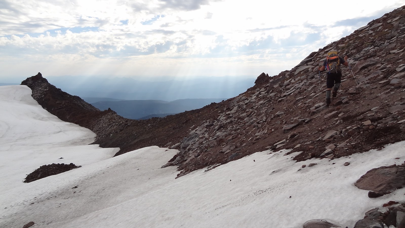
 I had hoped for open woods back to the PCT but instead go the exact opposite. What followed was nearly two hours of the worst descent from a peak I’d ever had. We found ourselves in very steep terrain that was completely overgrown with rhododendron bushes that were about 3-6 feet in height that we literally had to just fall down the hill through. In desperation I tried to traverse right back to the ridge to look for the climbers trail lower down but had absolutely no luck.
 At one point I found boot tracks but they didn’t seem to lead anywhere. It seemed to take us forever to descend that 2,000 feet through absolute hell. It nearly broke all our spirits completely. Apparently, Jefferson let us summit but it wasn’t about to let us out easily. Chris and I are usually pretty level headed in extreme situations like this but after falling and tripping probably 50+ times on the way down I heard a bit of rage from Holm that I never really hear.. the mountain was beating him.
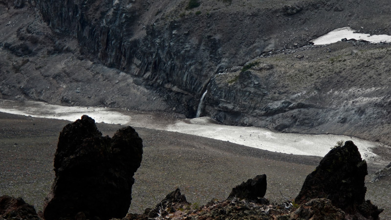
 When we finally stumbled our way out of the woods back to the PCT I knelt down and kissed the trail in absolute Joy. It was another 3 miles or so along the trail back to Pamelia Lake and water and all of us were extremely dehydrated but it felt like heaven to be on a clear path again. We stumbled down the trail with my legs shakier than they’ve ever been. I was dying for water and could almost smell it. If I was that thirsty I can’t imagine what Chris felt like. We only walked about a half mile before we had to put on our headlamps to see the way. We had barely made it off the ridge and out of the woods in time!
 Back at Pamelia Lake we met up with Cassie who had set up camp for Garrett. I figured Emily was probably panicked at this point so I downed a camelbak Cassie had and booked it out of the woods in the dark. On the way out alone I was constantly aware of the story Dan had told us about Cougers being along that trail. It didn’t take me too long to travel the 2.5 miles back out to the truck but when I got there I was so exhausted I forgot to step on the clutch to start the truck and thought for a brief moment my battery had died = spirit broken. Fortunately, I regained my wits and started the truck up for the drive out but about 10 minutes later the cooler of beer in my backseat spilled and killed the amp under my passenger seat forcing me to shut off the radio for the entire 2.5 hour drive back to Ridgefield. We hadn’t even stopped to drink a beer that Garrett had stashed at the lake for us on the return.
 I made it back to Ridgefield by about 11:30pm and simply passed out from exhaustion, so happy to sleep in the next day and relax after one of the hardest ascents of my life. Stats for the hike were 19.2 miles, 17 hours of non-stop hiking and nearly 8,000 feet of climbing. This was a hike that most people do in 3 days and we did it in 17 hours. I think we had definitely proven ourselves on this trip. Beautiful views at the top but I have no intention of climbing it again anytime soon!
No comments:
Post a Comment