
I had been planning a ski descent of Glacier Peak for 2 years and this past weekend I was finally able to accomplish that goal in an undertaking that proved to be the biggest mountain ascent of my life thus far. I had met Brayden a few months before on our ski descent of Mt. Hood and he luckily had the flexibility in his schedule between job and school to join me on the adventure. With 50-60lb packs we traveled 32 miles over 4 mountain passes, 4 glaciers, and ascended over 10,000 feet all so I could ski from the summit of my last US volcano in perfect weather. Click the title to read more about our adventure to the most remote Cascade Volcano in the United States… Make sure to scroll to the bottom for the video as well.

 With Brayden between working at Mountain Hardwear and going back to school this fall his schedule was as flexible as mine was allowing him to join me for a four day weather window in the Glacier Peak Wilderness area of northern Washington. I had just returned from a 4 day John Day River rafting trip over Memorial Day weekend where I returned home at nearly 10pm. This meant that I only had Tuesday and Wednesday to both see Emily AND keep up with a demanding project at work.
 Thankfully, Brayden agreed to leave early Thursday morning instead of Wednesday night. This actually proved to work out as it poured all night Wednesday and we would have been sleeping in the rain at the trailhead had we left that night. I was certainly happy to have another night with Emily before I took off again for another 4 day adventure.
 On Thursday morning Brayden arrived at our place at about 7:15 and we were on the road towards Seattle by 7:30pm. I had loaded up the iPad with imagery of our climb for him to review on the way up as well as GPS tracks from other climbers on both the iPad and my iPhone which I would use to navigate while on the ascent. We stopped at exit 129 which seems to be the best exit for trips to northern Washington. There is an Elmers, Shari’s, Starbucks, gas, and a Winco all right off the highway which covers all of the travel needs we might have. Emily and I had randomly stopped here for breakfast at Shari’s and food pickup at Winco. This time Brayden and I went to Elmers and also Winco. Gotta remember that #… 129….
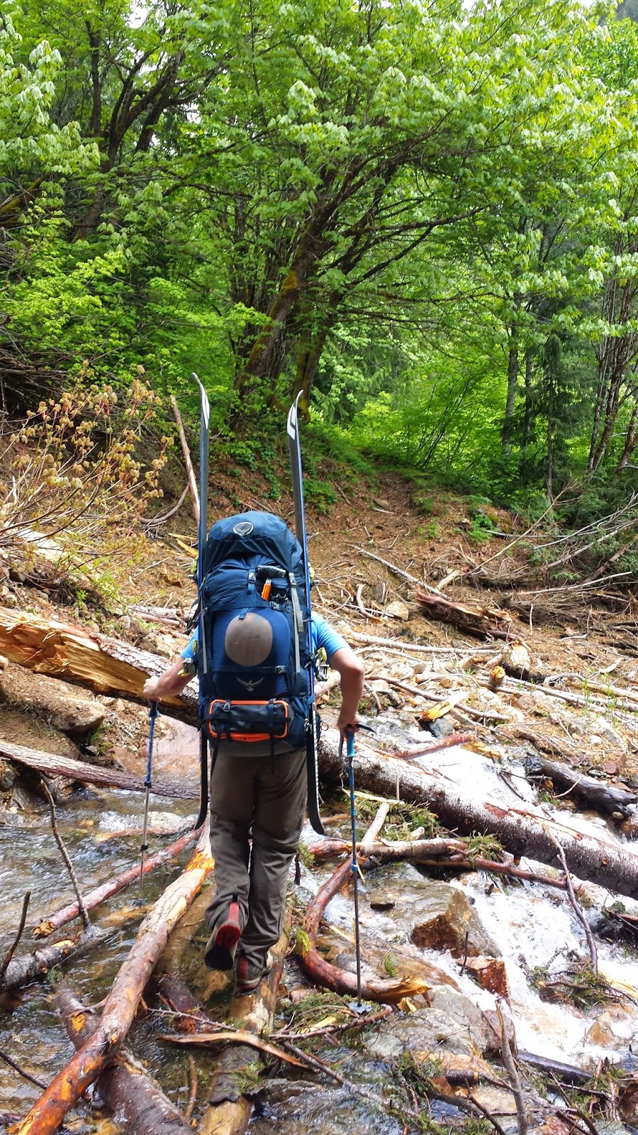
 After a great breakfast we drove through Seattle and took route 92 to Granite Falls where we connected with the Mountain Loop Highway that would take us to the trailhead. The normal route was to drive north through Darrington but because of the recent OSO landslide the route was closed, forcing us to drive 20+ miles on the dirt Mountain Loop Highway deep into the high, jagged peaks of the Cascades. Thankfully, we took my truck with new tires in 4x4 mode so we were able to shave an hour off the 5.5 hour drive to the trailhead, making it there around 1:30pm. With sunset at 9pm this left us just over 7 hours once we hit the trail to hopefully make it all the way to White Pass.
 We took the North Fork Sauk trail for just about 6 miles along the river to the base of the switchbacks that would take us up to where I hoped to camp the first night. We signed the register at the trailhead and headed down the trail at around 2pm with crazy heavy backpacks full of gear and our skis and ski boots. After the miserable trip to Jefferson 2 years ago with my Osprey Atmos bag (not built to carry heavy loads) I was so happy to have my new Osprey Aesther 85 pack that was super padded and built to carry immense weight. It was heavy as hell and I hard time picking it up but once on my back with the weight on my hips it wasn’t too bad.
 There weren’t any noticeable bugs as we made our way along the trail through massive old growth. It was still pretty cloudy from the rain the night before which we appreciated as it kept the temperature comfortable as we trudged along down the mostly flat trail. We started at 2100 feet at the trailhead and in 5.5 miles would gain less than 1,000 feet. At first we passed though a lot of skunk cabbage and devils club along the trail but then as we got deeper in it turned to old growth forest.
 About a mile in we had to cross an old landslide on some logs which was tricky but other than that the trail was perfectly maintained thanks to the diligent work of local trail crews restoring it after the 2006 storms that destroyed the area. It was a pleasant walk as we passed by massive old growth Doug Fir trees and some of the biggest cedars I had ever seen. We even got to see a large Pika on the trail at the base of a scree slope.
 We made great time and were at the Mackinaw shelter at the base of the switchbacks by 5pm where we stopped for a much needed rest before continuing on up the switchbacks (24 of them I believe I read from a blog). Brayden had packed in 4 pint cans of Hammer IPA which we stashed in the shadows of a big log hoping that nobody would find them. Little did we know that we wouldn’t see another soul until we were leaving on our last day.
 We ate some snacks and refilled Braydens water and then saddled up with our gear for the steep ascent towards the PCT and White Pass. At just over 4,000 feet we began to hit snow so we decided it was time to lose the hiking boots and strap into our ski mountaineering boots. Brayden left his in a plastic garbage bag along the trail and I made it a few hundred more feet before giving up myself and leaving mine in a big ziplock bag along the trail. I marked them with my iphone to make sure we’d come back to the same place to get them.
 It wasn’t long after leaving our boots that the trail became very hard to follow in the deep snow and we had to just point it up the hill towards the PCT, following the gps tracks on my phone from previous climbers. Brayden and I took turns breaking trail through the deep snow aiming up the slope for what we thought appeared to be the PCT, partially melted out on the south-facing slope. After 3 hours of steep switchbacks and trudging through the wet, heavy snow we reached the PCT, rounded a corner and decided to call it quits as we were both exhausted. In just under 3 miles from the Mackinaw shelter we had gained just under 3,000 feet. We figured nearly 4000 feet of climbing over nearly 8 miles for the first day to be sufficient and began to set up our sleeping spots right on the PCT for the night.
 There wasn’t much room for our stuff along the trail. I even had to chop out a bit of snow from the trail to make room for my bivy. We propped our gear up under a small tree and hoped the rain would hold off for the night. It was a little disconcerting watching the clouds move up the valley and envelope us as the sun set. It is rare that I actually get so tired in the mountains that I don’t even feel like eating. This was one of those times and looking back it was definitely the most tired I was on the entire trip.
 I eventually forced myself to get the stove going and boil water for both of our freeze dried meals as well as boil water to fill up Brayden’s water bottles. I honestly don’t remember even crawling into my bivy and I’m sure I was sleeping within seconds of putting my down jacket in my stuff sack pillow. We ended up about a 1.5 miles short of my goal of White Pass.
 We took our sweet time getting up on Friday morning. I woke up to find a chipmunk perched on Brayden’s skis next to my bivy. It was a beautiful morning of partially cloudy skies and crisp temperatures which meant the snow would be firmer and easier to walk on. Red Pass was right above us but it would have meant walking back along the PCT to get up and over it. Our other choice was to pass through White Pass and through a window in the next ridge to the White Chuck Glacier Basin.
 The gps tracks I had took us in this direction but looking back now I see that we could have gone over Red Pass from there as well. Red Pass would have added distance as it required backtracking but going forward towards White Pass meant a lot of side-sloping on steep snow slopes that heated up and became mushy under the sun. I’m not sure which would have been ultimately faster in those conditions but we chose to follow the tracks on my phone and head towards White Pass, leaving camp around 9:45am.
As we approached White Pass we began to have amazing views of the surrounding peaks such as Indian Head further along the ridge and the massive snow covered face of Johnson Mountain to our south. We also began to follow incredibly faint boot tracks from some climbers the previous week. This of course is always reassuring in the mountains, especially the fact that the log book at the trailhead said they had successfully skied off the summit as well. About this area was where we started to enter what I would like to call “Marmot Town”. They were everywhere around us, popping their heads out of their snow caves and whistling to each other warnings as we approached. We saw a bunch of smaller babies as well as several really huge adults which kept a close eye on us.

 Brayden was leading at this point and began to follow what he thought were the faint boot tracks up a steep slope above White Pass. I was following glad to have him kicking steps for a while and knew that the tracks were most likely marmot tracks but thought it would be fine because he was taking us uphill which is ultimately where we needed to be. I thought this would lead us to a window above White Pass where we could get some speed on our skis to get further towards our final pass into the glacier basin.
 Near the top I took over kicking steps and made our way up to the crest of the ridge only to be horrified to find huge cornices overhanging the bowl of White Mountain, prohibiting us from going any further. Much to the disdain of “Marmot Town” we were forced to put on our skis and descend through their main street back down to White Pass where we safely crossed over into the bowl of White Mountain without issue. We had been moving incredibly slow, less than a mile an hour, and losing this time got me worried.
 Below White Mountain we climbed as high as we could up the ridge we had just skied down to where the cornices stopped us, put on our skis and made our way across the sunny bowl of snow under huge hanging cornices (one had broken and slid down) towards what we could see would be our final window into the main Glacier Peak massif. When our speed died and we came to a stop we decided to put on our skins for the first time as the slope was finally gentle enough for us to keep purchase on easily.
This was a HUGE improvement over boot packing through the deep slush and we were able to increase our speed tremendously. With skins on we quickly made it to the window in the ridge where we were greeted with our first amazing views of Glacier Peak which seemed very, very far away….

 We rested for a while in the pass, eating some snacks and taking a bunch of photos of Glacier Peak in the distance. I wasn’t too sure where to go from here but thankfully I knew it was downhill into the base of the White Chuck Glacier basin. I didn’t want us to lose any elevation we didn’t have to so I took us on a very long and gradual descent skirting high up on the sides of the bowl we were entering to keep us as high as possible for the remainder of our ascent to our next camp spot which I hoped would be just below Disappointment Peak at “Glacier Gap”. On the descent we had amazing views of the very conical White Peak that we had just circumnavigated around.
 Once in the flat glacial basin skinning up towards our goal was easy and fast. Once again we located the faint tracks we had been following before and kept close to them as we ascended towards the White Chuck Glacier below Glacier Gap. We were skinning across the biggest glacial basin I had ever been in with the possible exception of my trip to Chamonix, France so long ago. We had left the pass at 2pm when we skied down into the basin and at 3pm just as we were getting to the base of the White Chuck Glacier and I could see Glacier Gap clearly ahead of us Brayden gave me very disturbing news.
 Apparently, the 28 year old, who was in far better shape than I, was in pain from an old T-band knee injury many years ago. He hadn’t felt it for years but the pain was returning quickly and he told me he was concerned about not making the summit the next day if we didn’t stop early on Friday. We were at 6700 feet when I wanted to be poised at 7500 feet a mile further up for our summit attack early the next morning. I won’t like when I say I was pretty heart broken as the weather was perfect and I had planned this for so long, but I know better than to tackle a huge volcano alone, 16 miles in the woods by myself. We decided that it would be best to stop there in a flat area and set up camp so his knee could have the rest of the afternoon to rest and heal up.
 We spent the rest of the afternoon relaxing in the sun, melting snow for water and eating Mountain House for dinner. I was happy Brayden had brought his tent matt and rainfly as it provided some shade for us out of the hot sun which reflected off the snow around us like a mirror. Our thermometer read 45-50 but it felt like 85-90 at times in the sun, especially when there wasn’t a breeze to flush the heat out.
 This was when it made it worth it to bring the iPad all the way in to the wilderness. We set it up under his rain fly in a shadow and watched the ski flick “Into the Mind” by Sherpas Cinemas which Brayden was impressed with. We had a beautiful sunset high on the glacier to watch after the movie and as I climbed into bed at 9pm for an early night for an alpine start the next morning I watched as the stars began to come out over the peak I desperately wanted to summit.
 On Saturday we got an alpine start for the summit, leaving camp at just after 4am in the dark. My goal was to see if we could make it up to Glacier Gap where I had hoped to camp by dawn which would put us in a good position for the summit…. and see how Brayden’s leg felt once we got there. Clear skies and cold temperatures over the night left the snow hard packed yet with a grip as I don’t believe anything actually froze. This resulted in some of the best snow for skinning on I had ever seen. We were able to skin up very steep slopes that otherwise would have sent us sliding later in the day and made it to Glacier Gap in just an hour as the sun began to rise over the North Cascades which we finally got a view of.
We took a break at Glacier Gap to eat some food and watch the sun rise over the jagged peaks to the north, lighting up the face of Disappointment Peak and Glacier Peak above us. Glacier had seemed so far away the night before but from here it didn’t look too bad just behind the smaller summer of Disappointment Peak. Better yet, Brayden said he leg felt fine and was happy to keep going. We took lots of photos at this spot and even got up close with what Jason Killian later told me was a ptarmigan. The bird just sat and watched us approach, perhaps keeping an eye on a nearby roost.

From Glacier Gap we descended on skis a short distance to the base of Disappointment Peak where we put on skins for the long, broad climb up it’s eastern face towards a window on it’s east ridge to the Cool Glacier and Glacier Peak behind it. This was a very straightforward climb and we occasionally caught glimpses of those same faint boot tracks along the way. Behind us, the broad Suiattle Glacier stretched out from Glacier Gap and the North Cascades came into clarity shedding their morning haze under the hot sun, without a cloud in the sky. There was a light breeze which kept us comfortable as we climbed in perfect weather but my heart sank half way up the face of Disappointment Peak when Brayden again said that he felt his knee going out…..

When we got through the window on the shoulder of Disappointment Peak we passed through it onto the Cool Glacier of Glacier Peak. Finally, we were officially on the Peak we came to climb. Brayden spotted a great spot above us in a wind block next to some rocks just below the summit of Disappointment Peak for us to take a break. Brayden said he didn’t want to push it to the summit as boot packing up the steep summit block would be the worse thing possible on his T-band. I had a choice to make.

Normally, I would avoid going for a summit alone, but in this case Brayden had made it to just 1,000 feet below the summit less than a mile away and could literally watch me climb the majority of the way up it. The weather was perfect and we had made it up there by just after 9 am. This meant the snow would still be firm, yet soft for climbing and skiing and the danger of rockfall on the face I would climb would be minimal as the sun was just starting to hit it. As a mountaineer you couldn’t ask for safer or better conditions. So.. I decided to go for it solo.

 Brayden assured me he had plenty of clothes to stay warm and would be more than happy to wait for me to summit. He and I spotted a steep slope that I was thinking about skiing down but it had some crevasses opening up at the base of it so I wasn’t too sure. I started off on skins up across the Cool Glacier. At this time of year the majority of the crevasses were still safely filed with snow so I wasn’t too concerned. There was a huge bergschrund up ahead at the top of the glacier field but there was a clear and safe path around it. I topped out on the ridge line between Disappointment and Glacier and could actually see a partially melted out path leading up the face of Glacier Peak. I had lost the faint boot tracks but the path reassured me and the tracks on my phone directed me where to go.
 I was able to walk up a little ways up the rocky path before having to put on my crampons on the icy slope. From there it was a slow safe climb up to the top. Nothing was falling off the rocks and I felt very safe and secure on the slope. When I got up to what I thought was near the summit a peculiar thing happened. I crested out of the chute I had climbed up and saw a huge broad summit stretching out before me. The true summit looked about a quarter mile away!
 I had read the summit was broad but damn, I wasn’t excited about having to hike that flat distance over mushy snow now under the sun…. Annoyed, I put my head down and started to trudge up the first bank of snow. I took about 30 steps up the slope and to my shock found myself standing on the summit! It was the oddest optical illusion I had ever seen in the mountains. What I thought was a quarter mile away from the glare of the sudden and flat light of the snow was actually about 50 feet! I was at the top!
 It was 10am at the summit. We had made incredibly great time from camp so I decided to take 20 minutes to explore the summit and really soak in the experience. I took probably a hundred photos at the top to later stitch together into panoramas and walked all around the summit for various views down all the faces of glacier peak. It had been great climbing all day with a lighter summit day pack but I was still happy to have it off my back for a little bit.
 I could see clouds in the distance gathering above the smaller peaks but around Glacier it was clear blue skies. I could see all the way south to Rainier and all the way north towards Baker and Shucksen and possibly even some peaks in British Columbia, Canada. Disappointment Peak and the rock outcropping where Brayden was waiting looked tiny 1,000 feet below me. I tried to call down to him as there wasn’t even a breeze at the top but my voice was shot from being so tired and I’m sure he couldn’t hear me.
 I poked around the summit looking for an entrance into the slope Brayden and I had scoped out for me to ski but I couldn’t tell where to drop in safely and knew there were cliffs below so I decided to just return and ski down the same way I had come up. But… before leaving the summit I needed to snap a few photos of me at the top for proof! This led to quite the scare for me! I spotted a big rock with a pile of crusty snow on the top of it just below the crest of the summit. I figured if I propped the DSLR up on my bag, set a timer and ran over I could snap a photo of myself standing on it with the north Cascades behind me.
 As soon as I jumped up on top of the rock I heard a tremendous roar… instantly thinking I had somehow triggered an avalanche or even dislodged the giant rock I was on. Nope, neither. It was an F16 jet that had decided to buzz the summit while I was up there. Phew… Heart racing, I climbed back down and headed back to my bag to get ready for the descent. After I got my GoPro running on my climbing helmet I headed down from the top the same way I had come up. The ski down from the summit was choppy and icy but as soon as I got over the ridge line between Disappointment Peak and Glacier I was on a slope that had been facing the morning sun and it was perfect spring skiing conditions!
In no time I was carving turns down the Cool Glacier back to Brayden who seemed very comfortable in the sun snacking on food waiting for me. After a quick break and scoping out our descent options we klicked into our skis and started a truly amazing ski descent down the face of Disappointment Peak back towards Glacier Gap. The snow was perfect but my legs were exhausted so we stopped a bunch of times on the way down to soak up the views and the experience of skiing the most remote volcano in America. We were completely alone on the 10,541 foot peak with mountains and vast glaciers stretching out all around us on a bluebird day in perfect, smooth and soft spring skiing conditions. It was one of those moments I’ll never forget.

At Glacier Gap we again had to put on our skins on to get up the slope but then we had another fun descent back towards our base camp. Before the camp we had to skin-up again for about half a mile to reach it. That would be the case for the rest of the trip… skins on, skins off, skins on, skins off. We were amused to see that Brayden’s fly and ground matt had flipped in the wind while we were gone.


 It was only 1:30pm which left the rest of the afternoon for us to relax on the glacier and soak in the views one last day. Thankfully, the weather had begun to cloud up which helped block the intense heat of the sun reflecting off the snow. The temperature change when a thick cloud passed over was truly amazing. It would go from what felt like 85 to about 45 degrees in seconds… Alternating from a t-shirt to a puffy jacket so many times began to be ridiculous. Several times throughout the afternoon F16 jets flew over us shaking the entire basin and flying well below the summit of Glacier Peak.
Brayden and I busied ourself with organizing our gear, melting snow, and snacking on the remainder of our heavy food. My feet were pretty messed up with blisters after the summit climb and ski so I used some of Brayden’s duct tape to tape them up for the descent the next day, letting them dry out in the sun before doing so. Later in the afternoon we again set up the iPad under his fly and watched “The Hangover” to kill time. Around 7 I headed over to my bivy and also watched the Hangover 2 which ended just in time for me to watch another amazing sunset over Glacier Peak.

 We woke up on Sunday to a complete whiteout. I could barely see Brayden’s tent 15 feet away. Thankfully, as soon as we started to organize and get ready the sun came out over the ridge line above us and baked the clouds away letting us once again see Glacier Peak in all its glory in the morning sun above us. On the way down from the summit the day before I had hit a soft patch of snow that pitched me forward and ended up breaking my climbing helmet straps (I think they were half torn before anyway).
On Sunday I strapped the GoPro to the headstrap attachment for the ski out. We re-traced our path from two days before and stayed high up on the walls of the basin to not lose any elevation. We had debated trying to get to Red Pass instead but it would have meant a long slog up a sun-baked slope further away so instead we opted to return via the route we knew.

 On the last descent down into the basin below the ridge we needed to cross over Brayden took a spill down a slope but thankfully his ski didn’t runaway on him or it would have literally traveled a mile or two deep into the basin… To reach the ridge line we skirted high up on the walls of the basin and then up onto the ridge. We had a marmot on the top of one of the ridge line crests watching us the entire time.
We boot packed up the ridge line to the highpoint where the marmot had been and then, after crossing over a huge cornice to a saddle, we put on our skis and traversed the steep slope back towards the window in the ridge we had passed through 2 days before. That is when we saw the first people of our trip. Two lone skiers were approaching up the valley far below us, apparently having come over Red Pass. We waved a greeting to them and yelled down for them to simply follow our tracks which they thanked us for.

It was a leg-burner traversing that slope back to the window and eventually when we reached our previous tracks we were forced to put on our skins for the last bit back to the saddle in the ridge. Once there we took a short break to get our heavy packs off our backs. We didn’t want to stay too long though as we had a lot further to go and the sun was rising in the sky which meant sticky snow on steep slopes = slow forward progress. From the saddle we pulled off our skins and had a pleasant traverse back to White Pass underneath White Peak. Thankfully, we didn’t notice any new cornice failures above us and enjoyed skiing past “Marmot Town” again with parents and babies watching us closely as we skied by their doorsteps.

From White Pass we stayed very high on the slope all the way past where we slept the first night on the PCT. We picked our path well but noticed significant melt from when we were there just a few days before. We had a couple sections where we had to kick off our skis and walk through brush to get through. Finally, we had a few fun turns before reaching our bootpack up from the switchbacks. There we changed out of our shells and thermals into our summer hiking gear and t-shirts for the long descent on our feet. Using our track from 2 days earlier I led us back through the woods to the official trail and eventually our hiking boots. Mine were just fine but Brayden found his in the middle of the trail out of the garbage bag with the tongues nibbled on! ha!

 After a painful non-stop descent down the switchbacks with our heavy packs under a hot sun we found ourselves back at the Mackinaw Shelter… and COLD BEER! Props to Brayden for carrying those 4 heavenly beers the first 5 miles on our first day. We took off our heavy packs and relaxed there for nearly a full hour, thankfully with a light breeze and bug-free. Brayden drank both his beers to take his mind off his leg for the final descent (he really manned-up) and I drank one and saved one for us to share at the trailhead once we were out. My legs had been wobbly coming down the switchbacks and I wanted to make sure I wasn’t tipsy on the way out to avoid rolling an ankle with my heavy pack.
 We rested at the shelter for over half an hour taking our time rehydrating and eating snacks for the remaining 5+ miles out along the North Fork Sauk River. We left the shelter at 1pm and I set the pace for the next 2.5 hours as we cruised along down the trail through the old growth forest making great time. We stopped a couple times but only briefly as we wanted to get to the trailhead and get the crazy heavy packs off our backs.
Our packs were lighter from less food but we made up the weight possibly with wet skins, wet skis and wet ski boots attached to them as well as the can of beer I was carrying out. We passed a few parties of hikers who congratulated us on our trip and crossed the log crossing with ease making it to the trailhead at about 3:30pm. We signed out at the register and after sharing the last beer and changing into some fresh clothes, hit the road.

 We made an initial wrong turn out of the trailhead which cost us 10 minutes of driving but took us beneath some really amazing peaks. We made it to Granite City by 5:30pm and in my rearview mirror I saw a place called “Barbeque Bucket”… Hell yeah! We sat down to cold beers and the best and meatiest half rack of ribs I’ve ever eaten. I think people were amused by us limping to our table.
 I called Emily and let her know we were down safely and that we’d be home around 9pm. From there it was an uneventful ride back through Seattle to home. We stopped for gas and an energy drink but I surprisingly wasn’t too tired. Although it was a long 12 mile day out we made great time and my new backpack held the weight well. The first day remained the most exhausting for me.
 Glacier Peak was the biggest climb of my life so far and one of the most rewarding for the effort involved. We saw a lot of wildlife, crossed over huge glaciers and I even got buzzed at the summit by a fighter jet. Brayden was a beast and fortunately made it out without any further knee injury. He was a great partner to have along on the trip and although he didn’t summit I know that I couldn’t have made the summit without his support along the way.
 Although we didn’t actually camp in any of the places I had planned our decisions turned out to be the right ones the whole trip based on the snow conditions and weather we encountered. Although some people can do this climb in 3 days, especially in the summer, I’m glad that we allowed ourselves a more relaxed 4 days. The area was absolutely stunning and I look forward to heading back to the wilderness in the summer with Emily and Leo for some backpacking with different views. Now to start planning those last 3 Canadian volcanoes to finish off skiing the Cascade Crest…
No comments:
Post a Comment